Where Did Your Ancestors Live?
This is probably one of the most common regrets: "I didn't get a picture of the home my grandparents lived in". It held some great memories, Now it is gone. Or, you have no photos of your parents' home where you grew up.
The wonderful trend of writing about and documenting where our ancestors lived, beyond just dates and places, should include a photographic history.
Now is the time to photograph the homes that still exist. It is so easy today; your camera, in the form of tablets and smart phones, is at your side nearly all the time.
Illustrate Your Family Story
More people than ever are writing books and blogs of their family history. Along with words, pictures add an additional dimension to a historical work. Everyone likes pictures; they help explain the words, evoke past memories, and certainly break up the monotony of lengthy text. Think about illustrating your thoughts with related pictures.
GPS for Location Help
Nearly 20 years ago an aunt of mine showed me the farm land where my father was born. The farm house was long gone, plowed under and a wheat field covered the homestead. However, the old pump, water well, and a concrete cap was still in place; the current farmer just plowed around them. I recently returned to the area to take some pictures. Alas, they farmer had finally removed the old pump, and I'm not sure where the house was.
Today, your mobile device can mostly likely capture the GPS coordinates anywhere you take a picture. In addition, the latest camera phones can embed the GPS coordinates in the meta data area of an image. Meta data is extra information like the date, time, and camera settings at the time the picture is taken.
Recent versions of image editing software (e.g. Photoshop Elements, Paint Shop Pro, etc.) can read the GPS coordinates embedded in the image file. You can transfer these coordinates to any family history documents. In addition, these coordinates can be entered into auto and mobile GPS devices and guide you and others right to the house . . . or where it used to be.
Google Earth for Context
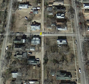
Besides capturing a picture of the old homestead and its GPS coordinates, you can look at the area using Google Earth. It is nice to have the GPS coordinates, but a view from Google Earth or even a map view will help you or others find the house, and this lets the reader see how the house fits in with its surroundings or neighborhood. |
Duplex wheremy great-grandmother and her daughter, my grand-aunt, lived from 1927 to 1930. Close to a trolley stop, the daughter rode it to a hospital where she worked as a registered nurse.
This GPS data is displayed in Photoshop Elements in FILE > FILE INFO in the Advanced tab. in the EXIF (Exchange Image File) properties.

A Google Earth view of the above house.
Save Screen Images
You can zoom in as close as you like in Google Earth, and then save the image by selecting FILE > SAVE > SAVE IMAGE and save the image to a folder on your computer. Including this image to your written family history brings even more context to the to the story. |
|
<